
blah blah blah
Black Mountain Pond
Length: 8.7 miles out-and-backDifficulty (click for info): Hard
Elevation Gain: 1010 feet (+100 feet on return)
Rating (click for info): 7/10
Elevation: 2212'
Driving Directions:
Trailhead and parking area are on Sandwich Notch Road in Sandwich, NH. (Seasonal road - check status on TrailsNH to verify gate status). From the center of Sandwich at the junction of Rt. 113 and Rt. 109, drive northwest on Grove Street, which becomes Diamond Ledge Road. In 1.9 miles, take a left at the T-junction onto Sandwich Notch Road. In 0.1 miles, bear left to stay on this road, passing through the seasonal gate. Drive 3 miles up the narrow, rough, and hilly road and take a left into the moderately-sized parking area, just after passing the trailhead and kiosk for Guinea Pond Trail and crossing the bridge over the Beebe River. Click here for a Google map.
About the Hike:
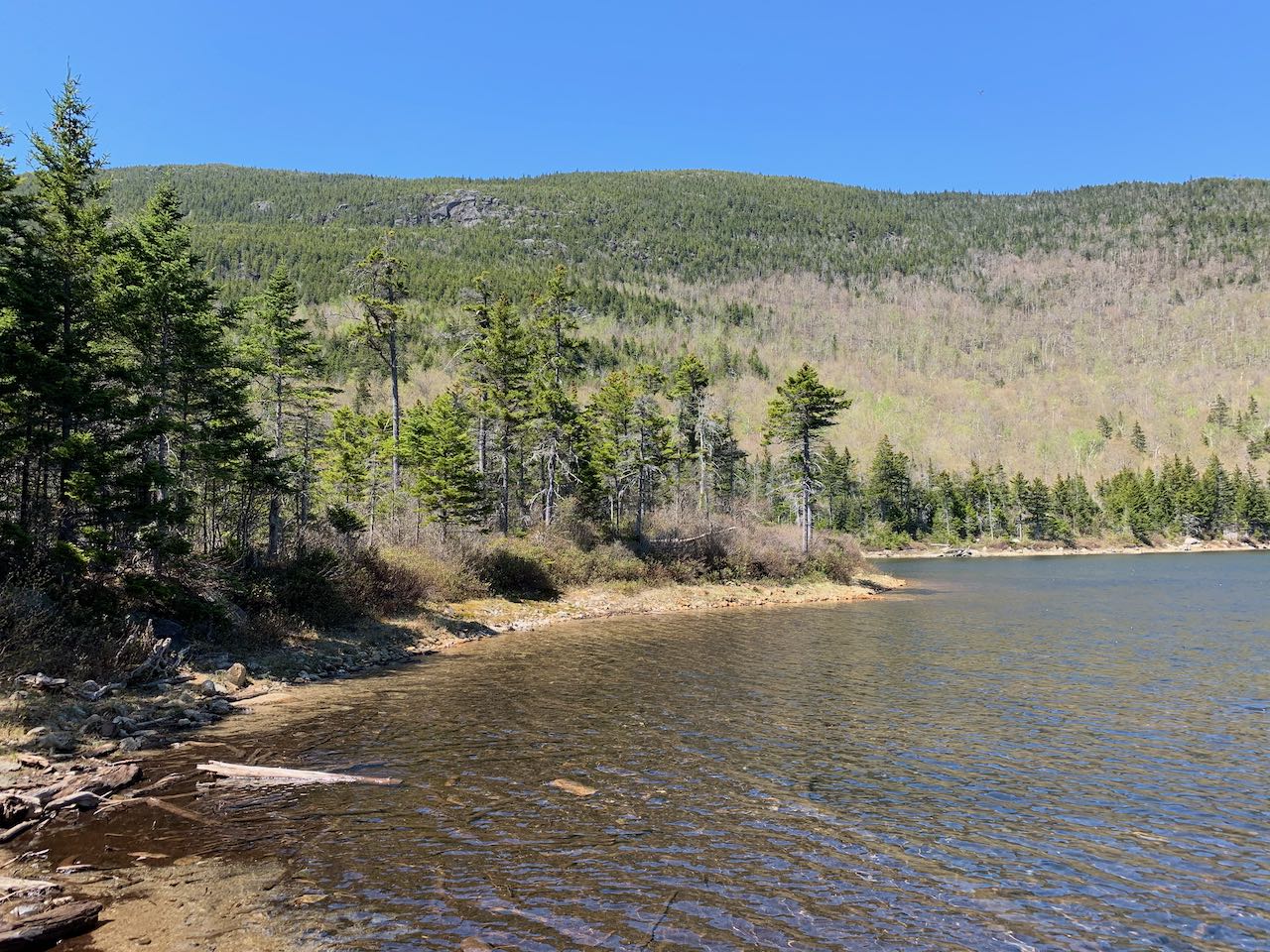
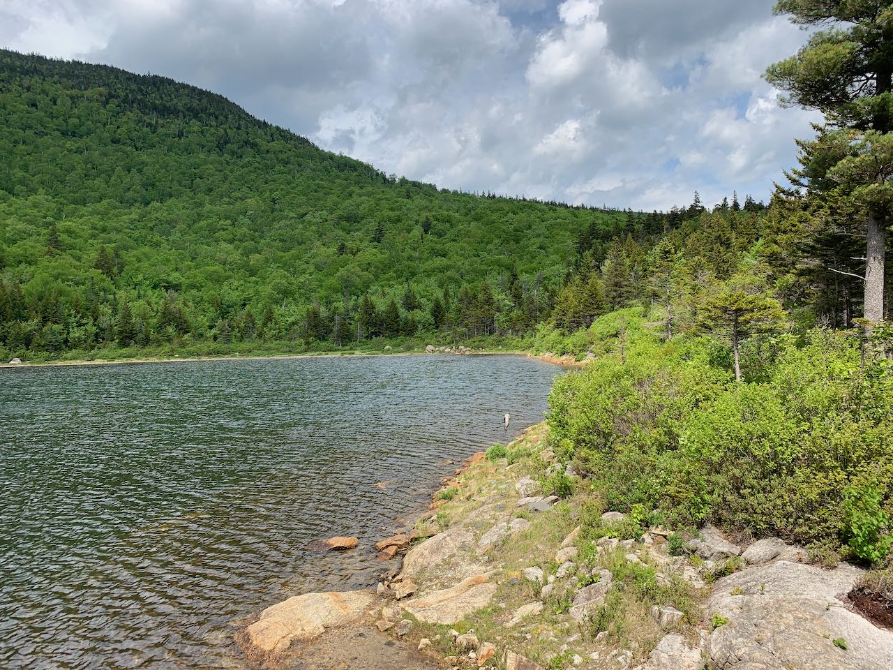
The corridor of the abandoned route through Sandwich Notch, now a historic forest road, is rich with pristine mountain ponds, but none stands out with such scenic beauty as Black Mountain Pond. Tucked away high up on a shelf amidst the sprawling fingers of Sandwich Dome, the shoreline of the isolated tarn offers clear views up to the rocky ridgeline of Black Mountain. The contrast of the rugged high terrain with the seclusion and peacefulness of the pond lend a sense of grandeur to the area. Far beyond the boundaries of the Sandwich Range Wilderness, it's a trek to get to the pond, making it a popular spot for camping. But the way is mostly easy and offers wonderful solitude in the woods. The trail intermittently follows the brook flowing out from the pond, which is the headwater of the Beebe River. In the higher terrain near the pond, it forms Mary Cary Falls as it tumbles over a hillside formed of ledge and boulders.
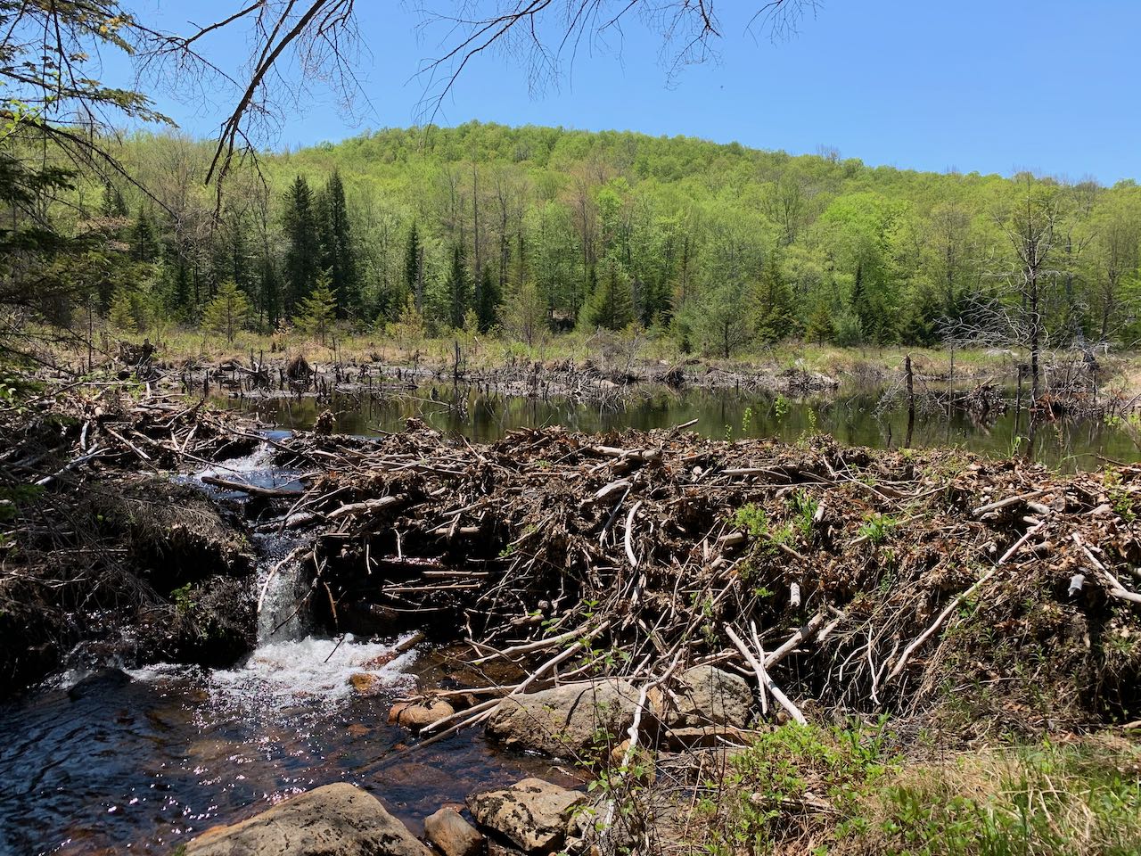
Begin your hike at an intersection of forest roads in Sandwich Notch. Walk out to the main road and head back the way you drove in for 350 feet, crossing the bridge over the Beebe River. Turn left onto Guinea Pond Trail at the kiosk, here beginning as a wide old road, shared with snowmobiles in the winter. After 0.15 miles on the trail, pass through a powerline cut, where the river rolls along in a ravine far below. The hike is uneventful for the next mile as you walk into the valley, with little elevation gain. The trail parallels the river from a distance as it slowly approaches an extensive wetland area. At the end of this section, it approaches a section where the main trail crosses through the wetland near the edge. The bed of the old railroad the trail was built from has lost the battle with beavers in recent years and will be flooded at all but the driest times of year. Look for a relocated section that takes off to the right just before the open area. Approaching this area and around it, there may still be flooding in mud season. It heads back across toward the powerline clearing, crosses it back and forth, and returns to the main trail on the other side of the wetland section after 0.2 miles. It continues on a narrower footpath close beside the edge of the wetland, where there is open water. Look through the trees for views over the wetlands to the side of Sandwich Dome. A quarter mile past the end of the bypass trail, arrive at a junction with Mead Trail, a route up to Mt. Israel. Just a few steps further, turn left onto Black Mountain Pond Trail. (You may find other guides describe a stop at Guinea Pond before continuing. 0.2 miles further up the Guinea Pond Trail, past two crossings of the Beebe River not far from each other, an unmarked trail takes off to the left and runs another 0.2 miles up to the shore of Guinea Pond. You will have to watch closely for the entrance to the path, as it is very little used and may be overgrown. Near the beginning of the spur, the way passes through another wetland and you may lose the trail in mud season. The trail fades out near the shore, but if you approach the water through the brush, you'll enjoy fine views of the whole Sandwich Dome ridge over the open water. We didn't include this side trip in the mileage for this hike because of the difficulties in getting to it, but it may be worth a visit if you are inclined and want to explore).
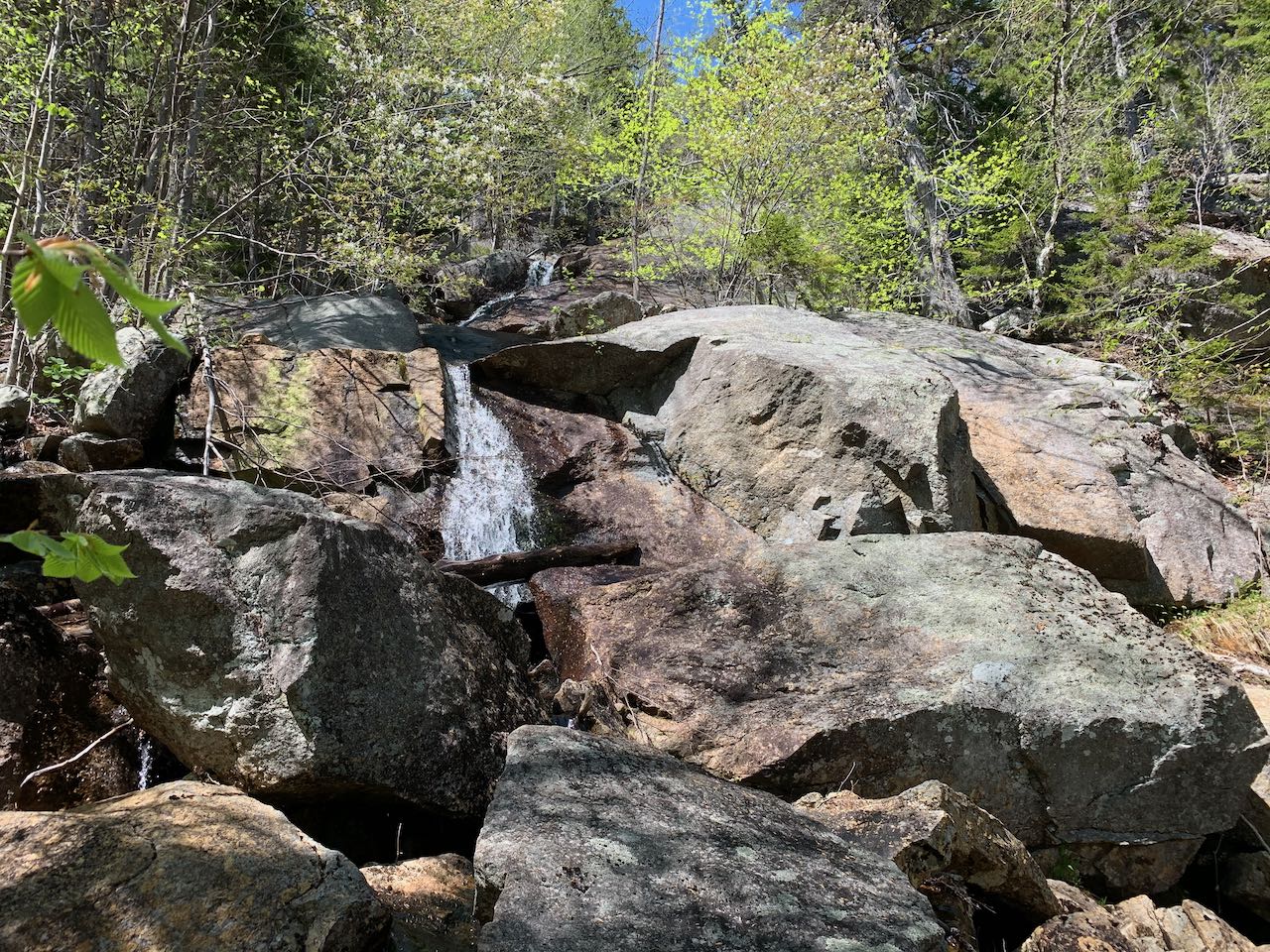
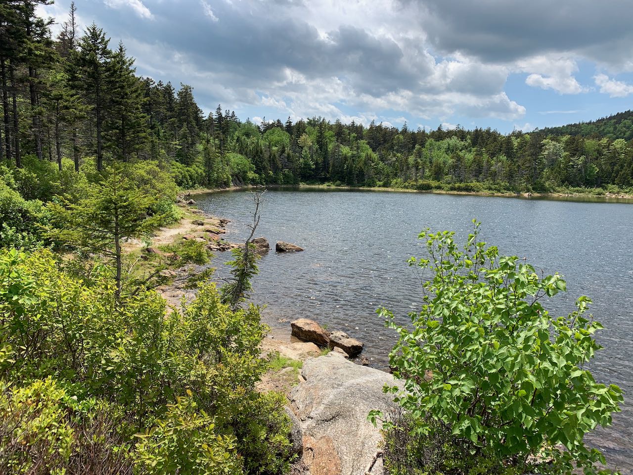
The trail dips down and right away crosses the Beebe River in a shallow and stony section downstream from Guinea Pond. Remaining at level grades, the trail crosses the official wilderness boundary, passes through a nice birch stand, and crosses a wet area on bog bridges. After 0.3 miles, it approaches the Beebe River again, now upstream of Guinea Pond (it takes a sharp turn flowing through the pond). It follows the bank of the river, here a wild mountain stream, over roots and rocks for 0.15 miles to where it flows out from a beaver dam in yet another open wetland. It crosses the river again on larger stepping stones and continues upstream, staying close by the river. It makes for a scenic streamside hike into the wilderness. It stays right atop the brookbank for 0.55 miles, passing little cascades through boulders and ledges. It then continues through bright, verdent forest as the brook veers away. Climbing gently, you gain elevation as you approach the lower slopes of Sandwich Dome. Deeper into the wilderness, spruce trees begin to mix in, and after 0.9 miles, reach a junction with a spur trail to Mary Cary Falls. Take a left and walk 0.1 miles back to the Beebe River, now a much smaller mountain stream, as it careens over a steep slope of jumbled rocks. The scale of the ledge in the hillside outsizes the flow of the waterfall most times of the year, but it's still a sight to see. Back on the main trail, ascend more steeply through much darker spruce woods for 0.2 miles, and cross back over the Beebe one last time. With that minimal climbing, the trail makes its way across the plateau toward the pond. After 0.15 miles, atop a bluff just in front of the pond, a spur trail leads through some tent sites to the shore of the pond. Walk along the grassy edge and you'll soon come to the outlet side of the pond, where you may have the nicest view over the round waterbody up to the profile of Black Mountain, a ridge of Sandwich Dome. There's plenty of room to explore around the edge of the clear blue waters. You can see up to the open ledges traversed by the Algonquin Trail high up on the ridge. You can get a different perspective from near the other side of the pond by returning to the main trail and continuing a bit further. The trail descends sharply and comes out to the pond's shore. From this side you have a view over the length of the pond to another of Sandwich Dome's lower ridges. You can also walk around a small peninsula from here to see a different side of the pond.
Printable directions page